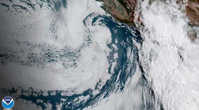
LOS ANGELES — With Hurricane Hilary barreling toward Southern California, officials are monitoring how the intense rain will impact critical infrastructure such as freeways, bridges and power lines.
Hilary will bring intense winds and rain across the region, notably in inland mountain and desert areas beginning Aug. 20 and into Aug. 21, with up to 10 inches of rain forecast. Officials have warned about flash flooding that could wash out roads.
“This has the potential to bring the single and most intense precipitation ever observed to some parts of the deserts in southeastern California, so don’t take this lightly,” said UCLA climate scientist Daniel Swain.
He advised desert residents to prepare for potentially impassable roads for an extended period of time. Rainfall amounts would be considered high even for places that aren’t so dry, Swain said.
“The potential is now very high for widespread flash flooding, and frankly severe flash flooding, that could verge on historic flash flooding. Even some interstates that go through the desert could become impassable, washed out, or potentially even see some bridges destroyed by the level of flooding that could occur.”
Swain added: “We’re talking about the type of flooding that will be life-threatening, that could severely disrupt or even destroy critical infrastructure, including roads and highways, leading to extended power outages or extended impossibility of travel in some areas.”
As soils become saturated and runoff accelerates off the San Bernardino Mountains, significant flows are expected to surge beneath the 71-year-old Whitewater Bridge on the 10 Freeway, about 5 miles west of Palm Springs.
That aging infrastructure has been a major concern for the state Department of Transportation because the Whitewater River flowing beneath it has a habit of abruptly shifting course during storms and scouring the rocky riverbed down to the bridge’s footing.
As Hurricane Hilary threatens Southern California, @Cal_OES would like to remind you how to stay safe during the event of extreme winds in your area. Learn more: https://t.co/oq5er36yTepic.twitter.com/nQL2QDQ1PW
— California Governor’s Office of Emergency Services (@Cal_OES) August 19, 2023
In 2017, the bridge was fortified with massive boulders and outfitted with highly sensitive “tilt meters” to monitor its movement.
On Aug. 18, the National Weather Service warned Coachella Valley residents to prepare for road closures. Stormwater raging down the Whitewater River is expected to reach Palm Springs late Aug. 20 and flow southward through the valley to Indio and beyond, possibly swamping escape routes along the way.
Here is the latest flash flood risk from #TropicalStormHilary. pic.twitter.com/xU08K2xUHW
— NWS Los Angeles (@NWSLosAngeles) August 19, 2023
The U.S. Army Corps of Engineers is coordinating with local agencies to ensure safety in and around its dams, levees and basins, according to Dena O’Dell, public affairs chief with the Corps’ Los Angeles District.
“The Corps will be monitoring the situation around the clock and that includes staffing dams and channels that may receive water flows this weekend,” O’Dell said.
She added that reservoirs owned and operated by the Corps in the Los Angeles area are empty and available to help manage storm runoff.
Though flooding is not anticipated on major river systems downstream of the reservoirs, localized flooding remains possible on smaller creeks and rivers, as well as flash flooding in desert areas, O’Dell said. Recent burn scars in Southern California and southern Nevada could also be subject to mud and debris flows, she said.
The Corps is working with local law enforcement agencies and homelessness advocates to help move unhoused people out of basins and river areas.
“This is not a time for people to be in those areas,” O’Dell said. “It becomes a life safety issue, especially because this is so rare for SoCal. It is not a time to be recreating in these areas, not a time to be living in these areas. We’re not trying to panic people, but we do want to make sure that they’re safe.”
Governor @GavinNewsom has proclaimed a State of Emergency for much of Southern California ahead of Hurricane Hilary to support faster recovery and response efforts.
Stay safe and listen to emergency officials. pic.twitter.com/jgzHrrWDPS
— Office of the Governor of California (@CAgovernor) August 20, 2023
Death Valley National Park was partially closed on Aug. 18 in anticipation of receiving more than its annual rainfall — 2 inches — which would be more than enough to cause major flooding in the hottest, driest place on Earth.
Flash floods were expected to cause power outages and damage roads, making it all but impossible to get in or out of the park, warned Abby Wines, a spokeswoman for the park.
“The public is encouraged to reconsider outdoor activities for this weekend,” Wines said. “Be prepared to turn around if you experience moving water on roads.”
On Catalina Island, officials have developed possible evacuation routes and rescue plans in case of emergencies. Officials have also added a third rescue boat on the island, said Los Angeles County Sheriff Robert Luna.
“It’s been 84 years since [a hurricane] came ashore, so it’s a once-in-a-lifetime event,” said Los Angeles County Supervisor Janice Hahn. “This is really an all-hands on deck effort.”
Zachary Plopper, senior environmental director with the Surfrider Foundation, said the giant surf projected along the storm’s path could exacerbate beach erosion and sand loss.
“With the big swells, we’d expect a lot of sand to move and wash away, so shore-front homeowners and businesses should be on the lookout for that,” he said. “Just treat it like a big winter storm, in a way, it’s just coming from a different direction.”
Hilary, currently a Category 2 hurricane, is expected to bring “life-threatening” rainfall and dangerous flash flooding from the Baja California Peninsula to southern Nevada over the next few days. The center of the storm is projected to reach Southern California by nightfall on Aug. 20, but its wide-reaching effects will be felt in the region much earlier in the weekend and continue through at least Aug. 21.
A high-risk warning for flash flooding was issued for much of inland Southern California — from the San Bernardino Mountains through the Coachella Valley and down into Anza-Borrego Desert State Park. This is the first time in more than a decade that such a warning has been issued for the low deserts east of the Southern California mountains, areas that remain typically dry, especially in the summer.
Some desert areas are expected to receive at least a year’s worth of rain during this storm, according to the National Weather Service.


